| Gauge Thai Side | Gauge Malaysia Side | Gauging Method | Flow Measurement Device | The Construction |
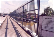
Over the years, the gauging team of the Department of Irrigation and Drainage (DID) has been carrying out streamflow measurements from the Golok River Bridge using a current meter mounted on a A-frame which travels along the downstream side of the bridges guard rail until high fences were erected at both sides of the bridges railings. Such fences have hindered the gauging operation for streamflow measurements.
In view of the importance of streamflow records of the Golok River there is always the need to continue flow measurements in order to archive continuous streamflow records. Such records will serve as the basic data and information for the planning, development and management of water resources of the Golok River basin.
To overcome the present gauging operation problem, an establishment of a cableway gauging station is deemed necessary. A cableway gauging station has been proposed at about 100 meters downstream from the Golok River Bridge at Rantau Panjang. The list of Malaysian gauging stations in Golok is shown as follows:

 |
 |
Existing High Fencing at Golok River Road Bridge |
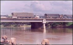
Sg. Golok Road Bridge. Upstream from Right Bank |