| Gauge Thai Side | Gauge Malaysia Side | Gauging Method | Flow Measurement Device | The Construction |
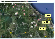 |
In Golok river basin, Royal Irrigation Department has set up 3 hydrological stations namely 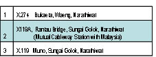 |
At the beginning, Thai side set up gauge station, X119 for measuring Golok water level. The X119 station was located at Long. 102° 58’ 40” E and Lat. 06° 04’ 09” N at baan Louk Seua Su-ngai Golok district, Narathiwat province. Golok water level was measured from 1980 to 2008 by two methods of reading
Water level—manual reading (Staff gauge) : 5 times a day (6.00, 9.00, 12.00, 15.00, 18.00 hr)
Water level—Automatic reading (floating gauge and Analog graph) : hourly recording and weekly collecting.
Later on, by the mutual cooperation between Thailand and Malaysia under the Golok River Mouth Improvement Project, Malaysia side proposed a cableway station to mutually measure Golok River discharge. Therefore two sides have established joint cableway stations, X119A for Thai side and 6019411 for Malaysia side.
For proper position for the cable towers of both sides, X119A is now located at Long. 101° 58’ 40” E and Lat. 06° 01’ 13” N, Sirindhorn Public Park, Su-ngai Golok district, Narathiwat province. Data reading at X119A are as follows
Water level—manual reading (Staff gauge) : 5 times a day (6.00, 9.00, 12.00, 15.00, 18.00 hr) from 1988 to 2008
Water level—Automatic reading (floating gauge and Analog graph) : hourly recording and weekly collecting from 2009 to present
River water level and discharge - small scale tele-metering from 2009 to present
River discharge—manual reading by current meter and cable set from 2010 to present